Where is the Cilmaengwyn tip?
- Save our Schools
- Apr 10, 2024
- 1 min read

The Cilmaengwyn tip was first recorded on NPTCBC asset register with the reference number L44
on the 19 October 2017. The authority have said they do not hold any records relating to any assessment at that time but say it followed an in house desk top review.

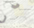
In May 2019, NPTCBC contracted consultants Earth Science Partnership (ESP) who defined an area of study for an assessment relating to the safety of Godre'r Graig Primary School as outlined in yellow. The majority of the land is located outside of the tip boundary as recorded in 2017.

Following the publication of a Wider Village Assessment in 2020, the suspected tip extent is shown to be refined to cover a smaller area.
In March 2020 the Welsh Government set up a national program of tip inspections.
Following a Detailed site inspection on 24 June 2023 for that national program the boundaries of the L44 are reported to be as shown below.

So where is the extent of the tip and which boundaries are correct?
The suggested remediation options were received by NPTCBC on 26 August 2021and the decision that demolishing the building was the only affordable option made on 2 December 2022. The reports presented at that time have been based on the 2019 study area.
The most recent detailed site inspection was undertaken as part of the Welsh Governments national inspection program in June 2023. It identified that the ground investigations by ESP are 'downslope of the tip'.
Neath Port Talbot have said they intend to continue with the Demolition of the School in April 2024 before the building becomes dilapidated.

